Showing posts with label River Medway. Show all posts

25 December 2020

A Royal visit to Upnor

The below image appeared in 'The Sphere' on 28th July 1956 and shows leading boy Barrie Dimmock (pictured right), from Buckinghamshire, receiving an award from Prince Bernhard of the Netherlands during a visit he made to naval training vessel Arethusa in Lower Upnor.


Cadet Dimmock was presented with the Rob Roy Cup and also received a number of other prizes.

Prince Bernhard toured the Arethusa, addressed the ship’s company and awarded numerous prizes to the assembled cadets. He also inspected a guard of honour and the ship’s band.

Arethusa was built in 1911 (in Hamburg, Germany), and was originally called Peking. She was purchased by Shaftesbury Homes in 1932, re-named Arethusa, and moved to Upnor in July 1933, where she became a training school and children’s home. In 1974, as Peking, she was sold to the South Street Seaport Museum in New York City where she remained until 2016 - when the ship was moved back to Germany. Peking is now undergoing a £23 million restoration and is set to become the flagship of a new maritime museum in Hamburg.

31 March 2017

The Dutch Raid and more!

With the 350th anniversary of the 1667 Dutch Raid on the River Medway being commemorated in June, don’t miss monthly guided walks at Grain Coastal Park (and take a look at some of the damage caused to the village church by raiding Dutch seamen).


In the company of volunteer Michael Dale (a member of the Friends of Grain Coastal Park), pictured above, the walks offer the opportunity to get out and about in the fresh air and to learn more about our local history.

There's lots to explore at Grain Coastal Park - enjoy!
  

7 January 2017

Digging up the Past

Ahead of gravel extraction from ‘Kingsnorth Quarry’ near Hoo, recent investigations by a team from the Museum of London Archaeology, carried out between September and October 2016, on behalf of Tarmac, found evidence of multiple periods of occupation.

Archaeologists working on site, after the topsoil was stripped.

Much of what was discovered appears to relate to features illustrated on 19th century maps, such as former field boundaries and the remains of orchards, although predictably the majority of the archaeological features were in close proximity to existing buildings or those shown on historic maps, including rubbish pits from the 18th to the early 20th centuries.

However, some pits contained fragments of medieval pottery – testifying to the continuous and lengthy occupation of the area.

Many pits contained Roman or prehistoric pottery, suggesting that the area may have been more densely populated in the past, but due to the effects of ploughing over several hundred years, only the base of these older features survive.

The only direct evidence for human occupation was recovery of partially disarticulated human bones mixed up in the lower fill of a pit, pictured below.  It is uncertain whether these remains represent one of more individuals or whether they were deposited as part of a deliberate, but unusual, burial ritual.

Human bones in probable Roman pit.

The remains were sealed under a layer of debris from a collapsed wattle-and-daub building.  An adjacent pit also had a layer of wattle-and-daub debris containing Roman pottery.  It is possible to speculate that these findings may represent the residents of a Roman settlement that might have succumbed to a violent and untimely end, although further analysis is needed by osteoarchaeologists to determine the age and gender of the remains and possibly the cause and nature of their demise.

Probable Roman field ditch (marked in yellow).

The Roman pottery recovered from the pits consisted of ‘Samian’ pottery, pictured below, a fine red tableware imported from Roman Gaul.  This distinctive pottery suggests some of the Roman features may date from the 1st to 2nd century AD.

Roman pottery from Gaul with maker’s stamp on base.

Other findings discovered included prehistoric pottery, suggesting occupation in the area may stretch back into the Iron Age or Bronze Age periods.

Information and images appear courtesy of Museum of London Archaeology, Andy Richmond of Phoenix Consulting Archaeology Ltd and David Brown of Tarmac.
  

31 December 2016

Historic barge in Hoo

The most well-known of the iconic sailing barges to have sailed along the River Thames arrived at Hoo Marina in early September, for winter storage, as she marks the end of her 110th year.


90ft-long sailing barge Cambria was built at the F. T. Everard and Sons Limited boatyard at Greenhithe in 1906 and is famous for being the last British registered vessel to carry cargo under sail alone – the final cargo being 100 tonnes of cattle cake in 1970 when she was owned by the folksinger and bargeman Bob Roberts.

Since being restored in 2007, thanks to £1.4 million from the Heritage Lottery Fund, Cambria has been able to provide life-changing experiences for hundreds of young people in association with the Sea Change Sail Trust as well as being hired out for private charters.  Cambria has also been active in the annual programme of traditional barge match races.

You can find out more about Cambria by visiting the Cambria Trust’s website here or take a look at the groups more up-to-date Facebook page here.

Photograph appears courtesy of Rob Powell at the Cambria Trust.
  

9 December 2016

Seeing old Friends at Grain Coastal Park

I visited Grain Coastal Park last weekend and bumped into my old volunteering colleague Michael Dale.

Michael is now a leading-light in the park’s Friends group – a group of volunteers (mainly residents from the Isle of Grain) who spend many hours each week working hard looking after this increasingly popular and vast open space.


The Friends of Grain Coastal Park group has gone from strength to strength since it was created back in January 2012, following a successful community project undertaken by the Kent Wildlife Trust throughout 2011, in collaboration with St. James, Isle of Grain, Parish Council.  Those early project sessions were lots of fun and very interesting.


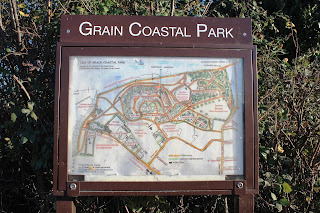
Michael and his volunteer colleagues have spent considerable time creating many great walks for visitors to enjoy.  In the noticeboard at the main car park (at the end of High Street, ME3 0BS) you will find a detailed map of the park showing all the walks.


If you’re looking to burn off some Christmas calories this weekend or during the festive period, or would simply like to get out of the house and enjoy fresh air and great views of the Essex coast and Isle of Sheppey – pop along to Grain Coastal Park.
  

3 March 2013

Hoo Marina is waiting for you!

I always enjoy popping down to Hoo Marina (now known as Port Werburgh). It’s high up on the list of places to go locally whenever I have family and friends staying over - just like when my mother and sister visited last summer.


Although you have to go through a small industrial area to get there, the views of the River Medway from the marina are worth it.

And, you can enjoy a nice cuppa and something tasty to eat at Hoo Riverside Diner - perfectly placed within the marina. Next door you’ll find the office of Premier Houseboats, offering a really interesting range of boats for sale - always good to have a nose at the sales board on the window!

From Saturday 9 March another business will be opening in the marina, next to Riverside Diner, called Beach Hut 'n' Boats. They’ll be offering a colourful range of products. Take a look at their website by clicking here.

Hoo Riverside Diner is open from Monday to Friday (8am to 4pm) and Saturdays and Sundays (8.30am to 4pm).

So, when you get some spare time, pop down to Port Werburgh and see what you’ve been missing!
  

20 February 2013

A high point in Hoo

It’s always nice to see where we live from a slightly different perspective. Towards the end of last year I joined local churchwarden Mick Hollands, pictured below, for a tour of the tower at Hoo St. Werburgh Parish Church.  We were joined by Michael Pearce, who runs Village Voices.


The battlemented tower, including spire, is more than 120ft tall, and the views from the top are quite fascinating.

The photographs below show (in order) Branta Fields, the centre of the village, the now defunct Kingsnorth Power Station, the River Medway and Church Farm Close.


If you’d like to find out more about Hoo St. Werburgh Parish Church, take a look at their website by clicking here.
  

16 April 2012

Stop the Thames Estuary Airport!

The campaign to prevent our area being destroyed by a Thames Estuary Airport has really taken off!

Medway Council, the RSPB and Friends of the North Kent Marshes continue to work hard, and in partnership with local residents, to prevent this catastrophe from happening.

My Photo Wall - a work in progress!

Although the media hype has calmed down in recent weeks, local residents are being encouraged to ‘keep up the pressure’ and maintain the campaign momentum.

That's why it is great to see more and more residents and businesses across the Hoo Peninsula displaying posters, leaflets and car stickers.

The dedicated Stop Estuary Airport campaign website, run by Medway Council, provides detailed information about where you can pick up leaflets, posters and car stickers. It also explains how you can get involved in the campaign.

As well as the Medway Council site, it’s also worth taking a look at the website run by the Friends of the North Kent Marshes by clicking here. The RSPB website also has an interesting section about the Estuary Airport proposals, with lots of useful and detailed analysis and information.

Step up, get up and together let’s Stop the Thames Estuary Airport from becoming a reality.
  

15 April 2012

News of Thames Estuary Airport proposals reach Switzerland

An unexpected package landed on my doormat yesterday, post marked Zurich. As I don’t know anyone in Switzerland, I wondered what on earth it could be!

It was from an organisation called SVS / BirdLife Switzerland and contained the latest edition of their magazine ‘Ornis’ - which reminded me of a request a couple of months ago from them to use one of the pictures from this website.


I don’t claim to be anything other than a keen amateur when it comes to photography, but it was nice to see one of my snaps actually published in a magazine. The image they selected shows a view of Hoo Flats, as seen from the Saxon Shore Way along the River Medway. The photo appears as part of an article about the Thames Estuary Airport proposals. Not speaking very good German, I’m afraid I can’t tell you ‘exactly’ what the article says.


Lots of interest in our little corner of the world. But not really a great surprise given that parts of our local area are internationally important to wildlife.

If you want to know more about why our local landscape is so important, visit the dedicated pages on the RSPB website here.
  

9 April 2012

High Halstow Walkers - April Walk (Sunday 15 April 2012)

The next walk organised by the High Halstow Walkers is taking place this Sunday (15 April).


Starting out at 10am, the walk will begin at the Kings Arms at the top of the High Street in Upper Upnor. Parking is available at the car park on Upnor Road.

The walk is being led by Alan Wilson and will go from Upper Upnor to Lower Upnor, Cockham Fort, Hoo Marina and then back. The walk, which I’ve done a few times myself, covers about 6 miles and follows the route of the old Saxon Shore Way. You can expect good views of Chatham Dockyard, St. Mary’s Island, the shore way, the river Medway and lots of fascinating local history.


So, if you fancy some fresh air, exercise and good conversation, this walk is for you. 

Other walks taking place this year are listed below. The start time for each walk is usually 10am, but confirmation of this, and meeting points, will be posted on this website every month.

13 May - Cranbrook and Sissinghurst. 10 June - To be announced. 8 July - High Halstow to Egypt Bay.

If you’d like to find out more about the High Halstow Walkers, get in touch with Mitchell by phoning 01634 254428 or send him an email here.
  

24 February 2012

Letter from America

Continuing my focus on some of the people who have recently been in touch to talk about their connections to the Hoo Peninsula, I am today looking ‘across the pond’ to the sunshine state of California.

I was contacted last week by Susan Cox (Sue), who lived in Hoo as a child in the late 1950s. Sue lived in one of the group of semi-detached houses next to Dr. Tilley’s surgery on Main Road. Sue says Hoo was lovely back in those days, surrounded as it was (and still is of course) by some beautiful countryside.

Main Road, junction with Tilley Close.

Sue’s father built a small boat for weekend jaunts on the River Medway and the river forts are imprinted in her memory from those trips. (Seeing these river forts up close is something I must try to do myself soon.) There was a meadow on the walk to the river, which Sue recalls was home to an enormous Suffolk Punch draft horse.


Her family had a housekeeper, who she thinks had many generations of family from Hoo. The housekeeper often used to take Sue and her sister to the Church graveyard to care for a family grave.


Sue also has fond memories of the old Post Office on Main Road, what is today Hoo Spice. Here is another photo from local resident Arthur Vidgeon’s website, as the building looked in 1915 - along with a photo taken a few days ago.


Thank you Sue for getting in touch and sharing your memories of living in Hoo.

Would you like to share your stories, memories or old photos of the area? Just get in touch via the contact page.
  

21 October 2011

High Halstow Hikers – upcoming walks . . .

A couple of walking dates for your diary . . .

November Walk

On Sunday 13 November the High Halstow Hikers will be walking along the Medway, taking in Teston, West Farleigh and Wateringbury - a varied walk with lovely views across the river. Just over 2 hours to complete, the distance will be about 5 or 6 miles. It might be muddy, depending on what the weather has been like, so wearing appropriate footwear is encouraged. Dogs will need to be on leads for much of this route. And for anyone interested - there’s excellent ale and food served in the Tickled Trout afterwards - so don’t forget to bring some money if you’ll be staying for food!

Setting out at 10am, the meeting point will be the public car park at the bridge by Teston lock - a short distance from the A26 on the B2163.

December Walk

On 18 December the group will be taking a local route right here on the Hoo Peninsula. It’s one of my personal favourites, taking in Northward Hill Woods and the farm tracks leading towards Cooling and the RSPB reserve at Bromhey Farm. This walk will take around 2.5 hours and cover 6 miles or so.

Meeting at 10am at the High Halstow Village Hall Car Park (The Street, High Halstow).


For further details contact Mitchell by emailing here, or phoning 01634 254428 - or if you want to join the group for one of these walks, just turn up!
 

13 January 2011

An artistic view from Upper Stoke

I recently bought this old postcard (series no 5396), entitled ‘On the Medway’, showing the Church of St. Peter & St. Paul in Upper Stoke. It was produced by Siegmund Hildesheimer & Co. Ltd, of London and Manchester, although it says it was produced in Bavaria.


With a strong family connection to Upper Stoke, this postcard is one of my favourite images of the area. I can't identify the name of who painted the picture or when that was, but is shows three small children walking through the churchyard with a dog running behind, boats on the River Medway, birds flying overhead and a traditional house behind the church.

Siegmund Hildesheimer & Co. Ltd were active between 1830 and 1920 and originally published books, but later moved on to producing Christmas cards, advertising cards, comics, art reproductions and real photo portraits.
 

7 January 2011

New Year’s Day Walk - Cliffe

On New Year’s Day, I headed for another RSPB Nature Reserve, this time at Cliffe Pools. I started out from Cliffe village on Pond Hill and then onto Pickles Way. Unsurprisingly, there were lots of people enjoying the fresh air and taking the opportunity for some exercise.

Although there are many trails to choose from, I opted for the Saxon Shore Way – heading through pools and lagoons towards Cliffe Creek.


When I arrived at Cliffe Creek, I had a look for Cliffe Fort, which was built in the mid-nineteenth century. Although derelict and closed to the public, it is still possible to view some of its exterior walls from the footpath. There are also the 100-year old remains of the Brennan Torpedo installation (on the shore side). Such a shame that these once important naval defences are now largely forgotten.


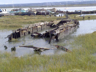
Within a couple of hundred yards of the fort rests the wreck of a Danish schooner, the ‘Hans Egede’. Although damaged by fire in 1955, she was used for many years as a coal and grain hulk on the Medway.


Heading back to Cliffe village, I took the less scenic, but more direct, route along Salt Lane, West Street, Higham Road and Church Street.

An excellent few hours spent exploring a small part of RSPB Cliffe Pools Nature Reserve, with some interesting local history along the way. I’ll certainly be back soon, as there are plenty more routes left to explore!

More information about RSPB Cliffe Pools Nature Reserve can be found by clicking here.
 

17 November 2010

Sunset over the Medway

These photographs were taken earlier this week near Kingsnorth Power Station, looking across the River Medway towards Gillingham and Chatham. Although a very cold evening walking from Hoo to Kingsnorth, the sunset views made it worthwhile.


21 September 2010

Support the Royal National Lifeboat Institution (RNLI) Special Appeal in Kent

The Hoo Peninsula is almost surrounded by water - with the Thames Estuary on one side and the River Medway on the other. Our area has strong links with the sea and increasing numbers of people use it for leisure activities, which is excellent and positive news.

As a teenager, I was proud to be a Sea Cadet. I really enjoyed my Duke of Edinburgh's Award assignment with the RNLI. I learnt many fascinating things during that time and I will never forget the dedication and commitment shown by the RNLI voluntary crew members.


According to the RNLI, last year was the busiest in their history and a lack of funds means there is a danger of them not being able to keep-up with increasing demand. In Kent alone, lifeboat crews were called out 411 times to help those in danger off the coast.

RNLI volunteers are not paid and they risk their lives to save others, and without public donations they would not be able to rescue anyone. If you would like more information about their vital work, or if you would like to make a donation, please visit their website.

10 September 2010

Saxon Shore Way, Hoo St. Werburgh

Having completed a small part of the walk along the Saxon Shore Way last week, between Upnor and Hoo St. Werburgh (described in another post), I completed another section today. This particular walk, centred around Hoo, is ideal for a Sunday morning stroll and takes less than a couple of hours to complete, especially if stopping to look at the views.

Information about walks on the Hoo Peninsula, including this one, can be obtained by clicking here.

I walked down Vicarage Lane to Hoo Marina and joined the clearly signed Saxon Shore Way path that runs along the River Medway to Kingsnorth. Soon after joining the path, you come across excellent views of Hoo Fort and Darnet Fort (in the middle of the River Medway). There are three WW2 pillboxes during the walk - an indication of how strategically important the area once was.

Altogether very enjoyable and a good mix of sights!